

IN FLIGHT ROBOTICS
Mining & Quarries.
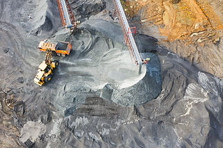
Accurate Drone Mapping for Mining & Quarry Operations
Our drone-based volumetrics and site surveys help mining and aggregate operators track stockpiles, optimize operations, and maintain compliance with reporting requirements. With fast service, competitive pricing, and proven mountain flying expertise, we deliver safe, reliable results even in challenging terrain.


Reduce survey costs and time by up to 50%
Cut survey costs and timelines in half with drone mapping that delivers precise volumetrics, 3d models, and compliance ready data.

Achieve accuracy up to 2–3 cm
Drone mapping delivers precise volumetrics and site models in a fraction of the time, reducing survey costs and improving planning.


Improve safety by removing crews from active zones
Eliminate the need for workers in dangerous zones. Certified drone inspections provide high resolution, repeatable data while meeting industry safety standards.

Fast turnaround with local knowledge and experience
Precision deliverables turned around quickly, and local knowledge of environmental conditions produce precise data when you need it.

⇥ Deliverables
→ Stockpile volumetrics
→ Orthomosaic maps
→ Topographical datasets
→ CAD ready data
→ 3D terrain models
→ Compliance reporting datasets
→ Slope profiles

